
Tree Survey in San Antonio, TX
Need a tree survey for your development project, building permit, or tree removal application? Alliance Land Surveyors documents every tree's location, species, diameter, and canopy spread to meet City of San Antonio tree preservation ordinance requirements.
Get Your Tree Survey Quote
Tell us about your project and property.
What Is a Tree Survey & Why Does San Antonio Require One?

A tree survey — sometimes referred to as a landscape survey or arborist survey — is a detailed mapping and inventory of the trees on a property. For each qualifying tree, the surveyor records the exact location, species, trunk diameter measured at breast height (DBH), canopy spread (drip line), and health condition. The data is compiled into a scaled survey map and a numbered inventory table that cross-reference each other.
In San Antonio, tree surveys are required by the City of San Antonio Tree Preservation Ordinance, codified in UDC Section 35-523. Before the City Arborist will issue a tree permit, you must submit a tree preservation plan that includes a professional tree survey showing every significant and heritage tree on the property.
The ordinance applies to new construction, site clearing, grading, subdivision platting, commercial development, and any project that may affect protected trees within city limits and the ETJ. Failure to comply can result in fines, project delays, and mandatory mitigation costs that far exceed the cost of the survey itself.
A tree survey from Alliance Land Surveyors includes:
Tree locations — each tree mapped to scale on a survey plat, with a unique ID number corresponding to the inventory table.
Species identification — every tree identified by common and/or scientific name to determine protected status under the ordinance.
Trunk diameter (DBH) — diameter at breast height (4.5 feet above grade), the measurement the City uses to classify trees as significant or heritage.
Canopy spread / drip line — the area beneath the outermost edge of the canopy, which defines the root protection zone during construction.
Health and condition notes — general assessment of each tree's health, structural integrity, and any visible disease or damage.
Property context — the survey also shows property lines, easements, proposed improvements, and existing structures to support site planning.

San Antonio Tree Preservation Ordinance — What You Need to Know
The City of San Antonio's tree ordinance (UDC Section 35-523) classifies protected trees by trunk diameter and sets strict preservation and mitigation requirements. Here's what developers, builders, and property owners need to understand.
| Classification | Minimum DBH | Preservation | Key Details |
|---|---|---|---|
| Significant Tree | 6" DBH | 35% minimum | Applies to most native tree species |
| Significant (small species) | 2" DBH | 35% minimum | Texas Redbud, Mountain Laurel, Persimmon, Condalia, Possumhaw, Hawthorne |
| Heritage Tree | 24" DBH | 100% preserved | Cannot be removed without Planning Commission variance |
| Non-native invasive | N/A | Exempt | Salt Cedar, Japanese Ligustrum, Paper Mulberry — excluded from survey |
If trees must be removed, the ordinance requires mitigation — either planting replacement trees (minimum 1.5-inch caliper) or contributing to the City's tree mitigation fund. Heritage tree removal requires a variance and City Arborist approval, and unauthorized removal carries fines and penalties.
The tree preservation plan submitted with your tree permit must include a sealed tree survey, a tree inventory with DBH calculations, and tree protection notes. Alliance Land Surveyors provides all of these deliverables.
Tree Canopy Surveys & Canopy Coverage Calculations
San Antonio's development regulations increasingly focus on tree canopy coverage — the percentage of a site shaded by tree canopy. A tree canopy survey measures and documents this coverage to support permitting, site planning, and environmental compliance.
What is a tree canopy survey?
A tree canopy survey measures the total canopy coverage across your property — the combined area of ground shaded by the outermost edges (drip lines) of all qualifying trees. This is expressed as a percentage of the total site area and is increasingly required by the City of San Antonio for development projects, subdivision platting, and environmental review.
Unlike a standard tree survey that inventories individual trees (species, DBH, location), a canopy survey focuses on the aggregate canopy footprint — how much of the site is covered by tree canopy before and after development. This data is used by planners and the City Arborist to evaluate whether a project meets canopy preservation goals.
Alliance Land Surveyors maps each tree's drip line (the outermost edge of the canopy projected onto the ground), calculates the total canopy area in square feet, and expresses it as a percentage of the total lot or development area. This data is integrated into the tree preservation plan and civil drawings.
When canopy coverage matters:
Subdivision and MDP submittals — the City of San Antonio may require canopy coverage data at the Master Development Plan or preliminary plat stage to evaluate a project's impact on existing tree cover across the development.
Tree preservation plan compliance — the tree ordinance (UDC 35-523) requires preserving 35% of significant trees by diameter inches. Canopy coverage provides a complementary measure that shows how much shade and environmental benefit is retained after development.
Edwards Aquifer and environmentally sensitive areas — projects in the Edwards Aquifer recharge zone or contributing zone may have enhanced canopy requirements as part of environmental compliance. Canopy data documents the baseline before disturbance.
Commercial development and site plans — some commercial projects and PUD (Planned Unit Development) applications require canopy coverage analysis as part of the development agreement or zoning case.
Mitigation planning — if canopy must be removed, the canopy survey provides the data needed to calculate mitigation requirements — how many replacement trees or what mitigation fund contribution is needed to offset the lost canopy.
What's Included in a Tree Canopy Survey from Alliance
Each tree's canopy edge mapped to scale, showing the actual ground coverage area
Total canopy area as a percentage of the site — before and after proposed development
Canopy polygons delivered in AutoCAD DWG with area calculations for your engineer
Tree canopy data is included in every tree survey or available as a standalone canopy analysis. Call (210) 369-9509 to discuss your project requirements.
Who Orders Tree Surveys in San Antonio?
Developers & Builders
Required before any tree permit is issued for new construction, grading, or site clearing. The tree survey feeds directly into your tree preservation plan and civil drawings.
Homeowners
Planning a major addition, pool, or significant landscaping change? If your project disturbs the root zone of protected trees, a tree survey may be required with your building permit.
Architects & Engineers
Tree survey data is essential for site planning — it shows where you can and can't build, where root protection zones restrict grading, and which trees drive your canopy calculations.
Land Planners
Subdivision platting in San Antonio requires tree data at the MDP or plat stage. The tree survey must be completed early to inform lot layout and preserve required canopy.
Environmental Compliance
Properties in environmentally sensitive areas, near the Edwards Aquifer recharge zone, or within floodplains may have enhanced tree canopy requirements. A tree survey documents your baseline.
Tree Removal Applications
Need to remove a significant or heritage tree? The City Arborist requires a tree survey documenting the tree's species, size, location, and condition as part of the removal permit application.
How a Tree Survey Works — Step by Step
Alliance follows a proven process to deliver tree surveys that meet City of San Antonio requirements and integrate cleanly with your civil drawings and permit applications.
 Click to enlarge
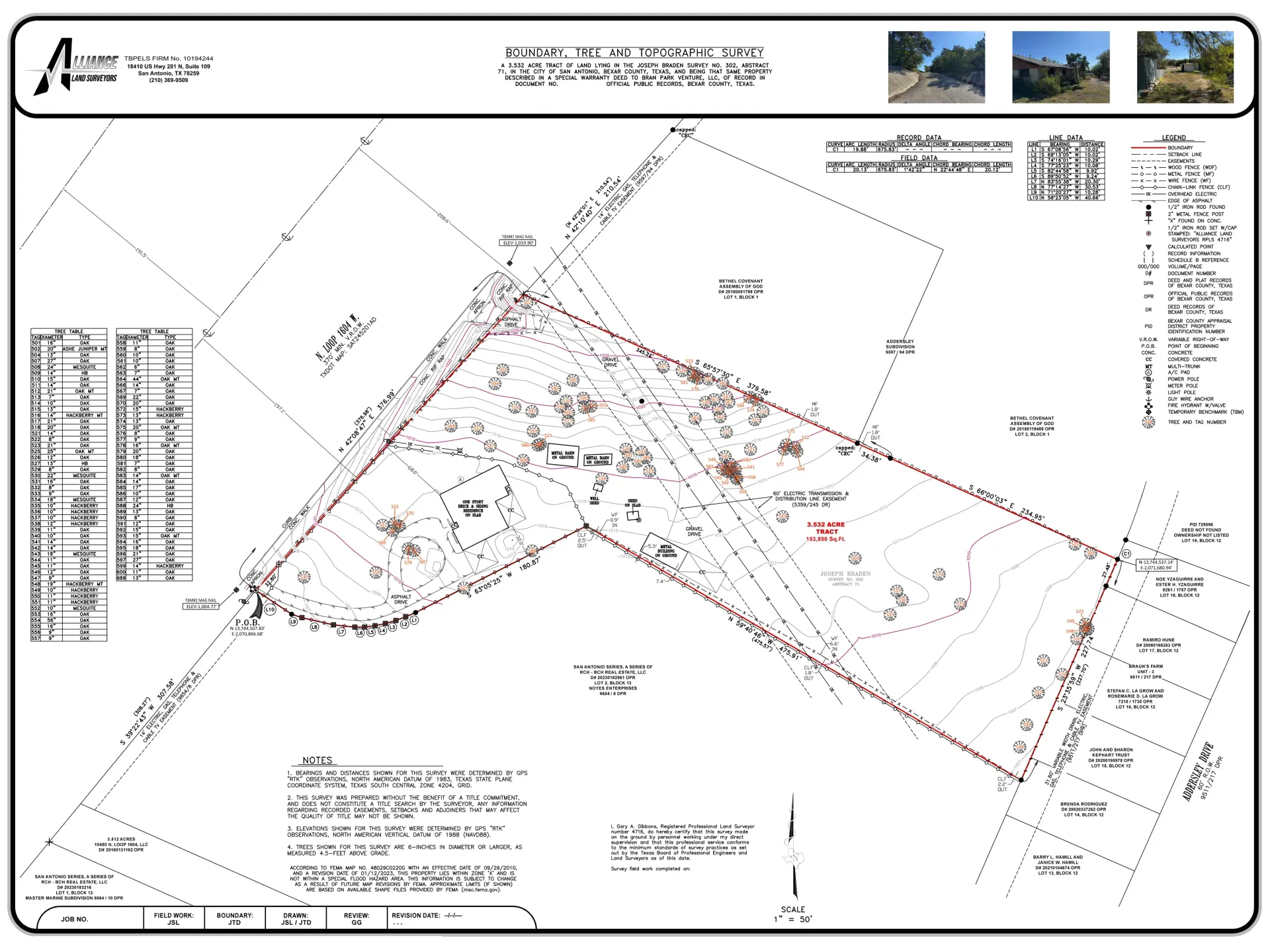
Sample Tree Survey
This is an example of a sealed tree survey produced by Alliance Land Surveyors. Each tree is numbered and mapped to scale, with corresponding inventory data including species, trunk diameter (DBH), and canopy spread. The survey is drawn on a tree preservation (TP) sheet that relates to the civil drawings.
Deliverables include: sealed survey plat, numbered tree inventory table, canopy/DBH calculations, and tree protection notes — everything the City Arborist needs to process your tree permit.
Request a Quote
Provide your property address, project type (new build, clearing, addition, etc.), and timeline. We quote the same business day. If you have civil plans or a prior boundary survey, send those too — they speed up the process.
Site Visit & Data Collection
Our survey crew visits the property to locate every qualifying tree using GPS and total station equipment. For each tree, we record the species, DBH, canopy spread, health condition, and precise coordinates. If requested, we tag trees with non-harmful numbered tags for field reference.
Inventory, Mapping & Calculations
Field data is compiled into a scaled tree survey map and numbered inventory table in CAD. We calculate total diameter inches, preservation percentages, and canopy cover to support your tree preservation plan and permit application.
RPLS Review & Delivery
One of our two Registered Professional Land Surveyors reviews the survey for accuracy and seals the document. You receive the TP sheet, inventory table, and calculations — ready to submit to the City Arborist with your tree permit application.
Combine Your Tree Survey with Other Services
Tree surveys are frequently ordered alongside other surveys for development projects. Bundling into one project reduces total cost since our crew is already on-site.
Tree + Topographic Survey
The most common combination. Your civil engineer gets elevation contours and drainage data while we simultaneously map every protected tree — one site visit, two deliverables.
Tree + Boundary Survey
If you need property lines established before the tree preservation plan can show which trees fall within the development area, combine both into one project.
Tree + Site Planning Survey
For architects and planners starting site design, a combined survey provides boundaries, topography, utilities, and tree data in a single coordinated deliverable.
Tree Survey FAQ — San Antonio
Request Your Tree Survey Quote
Whether you're starting a development project, applying for a tree permit, or planning a site design, Alliance Land Surveyors delivers tree surveys that meet City of San Antonio requirements — on time and on budget.
Get Your Free Quote
Include your property address and project type.
Tree Surveys for San Antonio Development Projects
Ordinance-compliant tree surveys starting at $400. Call for a free quote today.