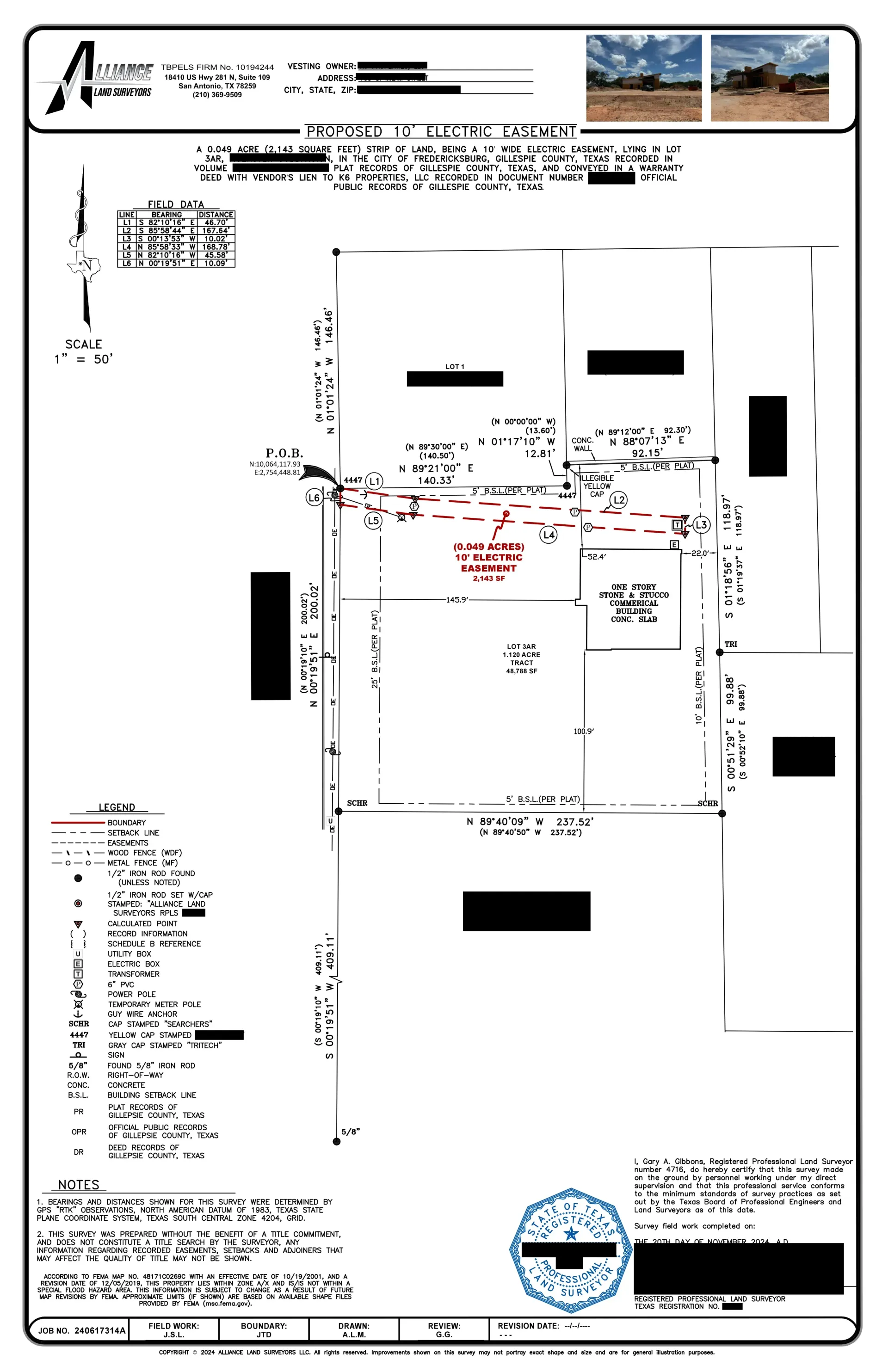

Easement Survey Services
Alliance Land Surveyors offers professional Easement Survey services designed to accurately map and document easement boundaries on your property. Our surveys are critical in verifying legal access rights, ensuring proper land use, and preventing encroachment issues before development begins.
Our Easement Survey Process
1. Preliminary Research & Documentation
We start by reviewing property records, deeds, plats, and zoning regulations to identify existing easements and restrictions.
2. On-Site Field Survey
Our licensed surveyors conduct an on-site survey using advanced equipment to verify and mark the location of easements and property boundaries.
3. Data Analysis & Verification
Collected data is analyzed to ensure that easement boundaries are accurate, clearly defined, and free from encroachments.
4. Final Report & Documentation
We provide a detailed, certified report including maps and documentation of all easement boundaries—vital for permits, legal records, and future planning.
About Easements
An easement is a legally binding right that allows a specific party to use a portion of another person's land for a particular purpose. Common examples include utility easements, access easements, drainage easements, and conservation easements. Easements are typically recorded in property deeds and play a crucial role in determining how land can be used.
Understanding easements is essential for property owners and developers. A clearly defined easement prevents disputes, protects property rights, and ensures that all parties have access to necessary services or infrastructure. Whether it’s a utility easement for power lines or an access easement for neighboring properties, knowing the exact location and scope of these rights is fundamental to responsible land use planning.
Our detailed easement surveys provide you with an authoritative map of all relevant easement boundaries, helping you avoid future legal complications and ensuring that your project proceeds smoothly.
Types of Easements and Their Uses
Utility Easements
Utility easements grant utility companies the right to install and maintain infrastructure such as power lines, water, sewer, or gas pipelines across a property. They ensure that essential services are provided even if that portion of the land is otherwise restricted from development.
Access Easements
Access easements allow a designated party—often a neighboring property owner—to pass through a portion of another’s land. This is particularly important for landlocked properties that require a legal route to a public road.
Drainage Easements
Drainage easements provide the necessary right to allow water to flow across a property, aiding in stormwater management and flood prevention. They ensure that water can be channeled away properly to protect both the property and surrounding areas.
Conservation Easements
Conservation easements restrict certain types of development to preserve natural resources, open spaces, or historic landmarks. These easements help maintain environmental balance and protect the ecological integrity of a region.
Right-of-Way Easements
Right-of-way easements grant public or private entities the legal right to pass through or use a portion of land. This type of easement is commonly used for roads, sidewalks, or other public infrastructure, ensuring community access.
Get Started Today
Ready to ensure your property’s easement boundaries are accurately mapped? Contact Alliance Land Surveyors today to request an Easement Survey and safeguard your development plans.